- Details
- Written by: ofurpaur
- Category: The Arctic
- Hits: 2946
Greeks were the first ones to name the Arctic. Based on the stars they saw up North, they named it Arktos, or the Great Bear. But a long time went by before Western people actually explored it, yet the name was made.
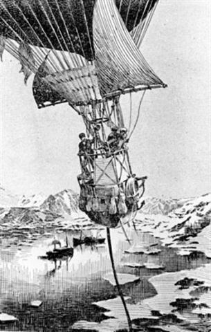
Three explorers are highlighted in this section: Robert Peary, Roald Amundsen, and Fridtjof Nansen.
Indigenous Peoples, Inuit and Mongolians, were the first to discover the marine routes through the North, which were used mostly for delivering community supplies, searching for food, and new settlement areas. For marine operations, they used kayaks and small man-powered boats with covered decks, which did not have ice-breaking capabilities but were light and easy to carry over the ice.
Pytheas exploration
The first European marine explorer was Pytheas in 330 BC, who is thought to be the first one to try to reach the North Pole. He was a Greek astronomer/geographer who had worked out a method of calculating latitude by measuring the shadow cast by a vertical pillar at the solstice. He had an idea of Thule, a place where the sun did not set in the summer and never came up in the winter, and was the first one to describe the Midnight sun and polar ice.
Pytheas' journey began in Marseille, France (then named Massalia) and lasted for six years. He reached Britain, kept heading north, and reached a place he called Orcas, which are considered to be the Orkney Islands.
He reached even further, but it is debated where he actually landed. Most likely, his final destination was Norway, though some say Iceland, which is highly unlikely since he sailed for only six days from Orcas. Yet another says it was the Shetland Islands.
After Pytheas' journeys, it took some time before Arctic exploration began again. In 1497, Giovanni Cabot was given permission to find a route to China. He landed in Newfoundland and then went back to England. He tried again but failed and lost all his men in the blistering cold. A story about a North-East passage was although born.
Captain James Cook exploration
Exploration of Arctic waters did not bring any results until the 18th century, when British captain James Cook decided to explore the northern Pacific Ocean. Captain Cook started his journey from Great Britain, and after a few months, he arrived at Cape Town in South Africa, from where he sailed through the Indian Ocean to New Zealand, the Cook Islands, and Tonga, all the time heading for Alaska. Cook never reached Alaska, and his journey ended in Hawai'i in 1779. He never fully explored the route, but his expedition had a significant impact on future explorations.
Other explorations
In 1845, another British polar explorer, John Franklin, sailed through the last unnavigated part of the Northwest Passage, proving its accessibility. Unfortunately, Franklin´s expedition did not survive the journey, but it became the bedrock for the 20th-century scientific researchers and inspiration for Roald Amundsen's voyage, who at the very beginning of the 20th century managed to complete the Northwest Passage from the Eastern to the Western part of the world. In 1942, when the Japanese Navy attacked Colombo in Sri Lanka and assaulted the United States on the Bataan Peninsula, the transit from West to East was completed by Henry Larsen.
Source: The Arctic by Richard Sail
- Details
- Written by: ofurpaur
- Category: The Arctic
- Hits: 6753
To describe where the Arctic is, we need first to define what the Arctic is.
Although anybody may point where the Arctic is, that is to say, that portion of sea and land surrounding the North Pole or, in more in general, that northernmost portion of the Northern hemisphere, “there is nothing intuitively obvious about the idea of treating the Arctic as a distinct region” (Arctic Human Development Report I). In fact, the definition of the Arctic has represented and yet represents an issue per se, and yet no single, clear cut boundary currently exists. Rather, the definition of Arctic very much depends on the features highlighted.
Definition of the Arctic
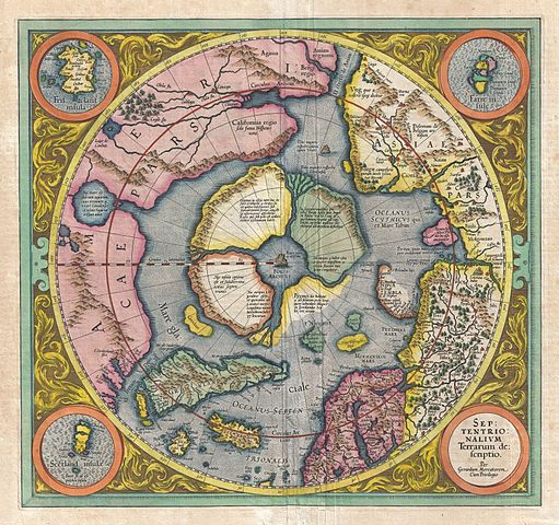
The word “Arctic” derives from the ancient Greek, arktikos, literally meaning “of the Bear ”, referring to either the Ursa Major either the “Ursa Minor” constellation, in any case, an idea pointing the geographical North. For centuries, the Arctic was vaguely considered as the northernmost lands and waters of the northern hemisphere, with no clear knowledge of it. In fact, even if the Arctic regions have been inhibited for millennia by indigenous populations (for example, the earliest known cultures in Greenland, the Saqqaq culture, is dated 2500-800 BC), Western societies had little knowledge of, and interest in, the area, until very recent times. Knowledge of the area has been a slow and progressive process started centuries ago, and yet not fully accomplished, as described for instance by the former Icelandic President Ólafur Ragnar Grímsson’s famous quote “we know more about the moon than the Arctic”.
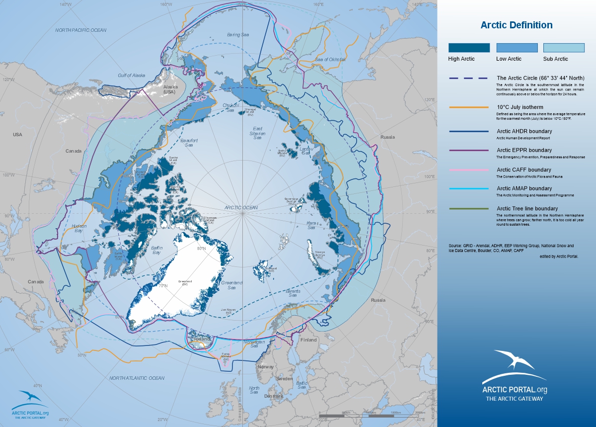
In contemporary times, the Arctic region has been primarily defined as this portion of land and water above the parallel 66° 33’’ 44’’ North, that is to say, the “Arctic Circle”. This imaginary line circling the globe marks the latitude above which, in theory, the sun never sets on the summer solstice, June 21st and never rises on the Winter Solstice, December 21st. However, due to refraction and other physical effects, the “midnight sun” may be seen also at lower latitudes.
Understandably, the portion of the globe described by the Arctic Circle does not follow any specific criteria, separating contiguous areas potentially homogenous. Indeed, additional biophysical and other criteria have been progressively outlined to encompass a more homogenous region surrounding the North Pole.
Among these biophysical criteria still in use, is the 10° July isotherms, defined as being the area where the average temperature in the warmest month (July) is below 10ºC / 50ºF.
Tree-line
Another criteria in use, for instance, is the tree-line. The tree line or timberline is the edge of the habitat at which trees are capable of growing. Beyond the tree line, they are unable to grow because of inappropriate environmental conditions (usually cold temperatures, insufficient air pressure, or lack of moisture). At the tree line, tree growth is often very stunted, with the last trees forming low, densely matted bushes. If it is caused by wind, it is known as krummholz formation, from the German for 'twisted wood'. The tree line, like many other natural lines (lake boundaries, for example), appears well-defined from a distance, but upon sufficiently close inspection, it is a gradual transition. Trees grow shorter towards the inhospitable climate until they simply stop growing. Extremely cold temperatures can result in freezing of the internal sap of trees. In addition, permafrost in the soil can prevent trees from getting their roots deep enough for the necessary structural support. Because the climatic zone in which the high-latitude timberline occurs is almost entirely under water in the Southern Hemisphere, this timberline exists only in the Northern Hemisphere. It crosses northern Siberia, Alaska, and Canada, and far-northern Scandinavia.
The above definitions based on biophysical criteria, while defining a portion of territory with very homogenous physical characteristic, have turn out to be unsuitable in defining a region under common economic, political and social features.
Geopolitical relevance
As the geopolitical relevance of the Arctic has been constantly growing over the last few decades, so has the interest in defining its borders. However must be bear in mind, as stated above, that “when defining Arctic regions, it is understood that no single, clear cut boundary exists to delineate their extent. Rather, this boundary will change with its application: environmental, biological, economic, jurisdictional, or social” (Grid-Arendal).
Arctic and the Arctic Council
An extensive work aimed at better outlining an economically/socially/politically homogenous region to be called “Arctic” has been initiated during the late 90’s by the Arctic Council Working Groups, which were in need to define the boundaries of their mandate. In fact, although the Arctic Council counts of 8 Arctic States Members (Canada, USA, Iceland, Kingdom of Denmark, Sweden, Norway, Finland and Russia), not the whole territory of these countries can be considered as Arctic.
The Arctic Monitoring and Assessment Program (AMAP) has first defined a regional extent based on a compromise among various definitions:
AMAP
"Given the different definitions of the Arctic, based on physical-geographical characteristics as described above, and those based on political and administrative considerations within different countries, no simple delineation of the Arctic region was applicable for the purposes of the AMAP assessment. To establish a geographical context for the AMAP assessment, therefore, a regional extent was defined based on a compromise among various definitions. This incorporates elements of the Arctic Circle, political boundaries, vegetation boundaries, permafrost limits, and major oceanographic features. The region covered by AMAP is, therefore, essentially the terrestrial and marine areas north of the Arctic Circle (66°32'N), and north of 62°N in Asia and 60°N in North America, modified to include the marine areas north of the Aleutian chain, Hudson Bay, and parts of the North Atlantic Ocean including the Labrador Sea. As stated above, the AMAP boundary was established to provide a geographical context for the assessment, in particular source-related assessment issues, i.e., consideration of sources within and outside the Arctic. The relevance of the AMAP boundary varies when considering different issues, and it has therefore been applied accordingly. Thus, contaminant levels in biota are addressed in relation to the geographical occurrence of the species concerned; demographic data are discussed in relation to administrative regions on which, for example, census data are collected.
(AMAPs 1998 assessment report, pg. 10)
Arctic Human Development Report (I and II)
The Arctic boundaries as defined by AMAP have been the ground for several following well-known definitions, as for instance the Arctic Human Development Report I and II, one of the most used definition nowadays: “For this reason, the AHDR takes as its point of departure the region that the Arctic Monitoring and Assessment Program covers in its 1997 and 2002 reports (4-5). For reasons having to do mainly with the location of jurisdictional or administrative boundaries and the availability of data, however, the area covered by this report differs from the AMAP Arctic in some respects”.
The AHDR’s definition embraces a rather homogenous cultural, social and economic region, considering the Arctic that area of 40 million km2, that “encompasses all of Alaska, Canada North of 60°N together with northern Quebec and Labrador, all of Greenland, the Faroe Islands, and Iceland, and the northernmost counties of Norway, Sweden and Finland. The situation in Russia is harder to describe in simple terms, as demarcated by our demographers, encompasses the Murmansk Oblast, the Nenets, YamaloNenets, Taimyr, and Chukotka autonomus okrugs, Vorkuta City in the Komi Republic, Norilsk and Igsrka in Krasnoyarsky Kray, and those parts of the Sakha Republic whose boundaries lie closest to the Arctic Circle”.
CAFF
Other, as the Conservation of Arctic Flora and Fauna (CAFF), another AC Working Group, has developed their own boundaries, which are defined as much by political boundaries as by climatic and biological zoning, and “largely follows the treeline in order to include the ecosystems that are the focus of its activities” (Although the Arctic Biodiversity Reports follows “a more scientific definition of the Arctic”, that is to say, the Circumpolar Arctic Vegetation Map’s (CAVM Team 2003) definition of the Arctic).
So, where is the Arctic?
This brief overview has shown that, although generally understood as the region around the North Pole consisting of a large Ocean surrounded by land, there is no universal definition of the Arctic. Depending on the criteria in use, large areas of the Northern hemisphere may be or may not be described as "Arctic".. As accurately described by Grid-Arendal, "when defining Arctic regions, it is understood that no single, clear-cut boundary exists to delineate their extent. Rather, this boundary will change with its application: environmental, biological, economic, jurisdictional, or social” (Grid-Arendal).
- Details
- Written by: ofurpaur
- Category: The Arctic
- Hits: 15679
The Arctic region has many faces. Historically it has been veiled by an aura of mystique, a frozen wonderland untouched both by the outside and the effects of industrialization, populated by a mysterious group of people from a different phase in the history of man. As interesting and romantic this notion may seem, it holds little or no truth in the Arctic today.
The Arctic is literally on top of the world, the earth rotating around the two poles, in the North and the South. But the Arctic is not just about the North Pole - the Arctic region stretches much further in all directions, even spliting the earth into the East and the West, famous identities in the world history.
Once a joke about vast wilderness where nobody ever went, the Arctic is becoming increasingly popular in many ways making the life of the 4 million people living in the region both scary and exiting at the same time.
Climate change is the one major denominator for the change in the region today. Because of its clear visibility in the Arctic, peoples eyes have moved north in recent years.
While the melting sea ice has led to problems for local people to practice their traditional livelihoods, it has also created unprecedented opportunities, including shipping in the Arctic. By sailing through the Arctic Ocean, the shipping route from Europe to Asia is significantly shorter and therefore very attractive for shipping companies.
In addition, enormous amounts of resources lie in the area, including oil and gas reserves that are extremely valuable. Resource exploitation has already begun, but the challenges are many when the area is so big and so far from any infrastructure.
The Arctic is thus both an industrial region, as well as a region in close connection to its history and culture. A mixture of traditional subsistence activities as well as a part of the global market economy. The new and the old submerge to strenghten each other with new technology and knowledge, contributing to a cultural rejuvenation occuring in the Arctic.
With more research and more interest from policy makers in the Arctic, they eyes of the media has also cantered further to the north. With more media attention the general public learns more and more about the Arctic.
But what exactly is in the Arctic? Who lives there? What animals live there? What is it all about? The Arctic Portlet seeks to answer all the general questions about this exciting area giving the readers an insightful peek into one of the world's last true wildernesses.