- Details
- Written by: ofurpaur
- Category: The Arctic
- Hits: 1773
The Arctic is one of the coldest and most extreme environments on Earth, with winter temperatures plunging to -40°C (-40°F) or lower. Despite its harsh climate, the region is home to a surprisingly rich and diverse range of animal life. Over 5,000 species of mammals, birds, fish, and invertebrates thrive in the Arctic, having evolved remarkable adaptations to survive the cold, seasonal darkness, and ice-covered landscapes.
Wildlife and Adaptation
Arctic animals display a wide variety of physical and behavioral traits that enable them to live in such a demanding environment. These adaptations include:
- Thick fur or blubber for insulation, as seen in polar bears, musk oxen, and seals.
- Seasonal camouflage, like the Arctic fox and ptarmigan, which change their coat color from brown or gray in summer to white in winter.
- Hibernation or torpor, practiced by species such as the Arctic ground squirrel.
- Migration, a strategy used by many birds and marine species to avoid the most severe winter conditions.
- Specialized hunting and foraging behaviors, such as the polar bear’s ability to detect seals beneath the sea ice.
Climate Change and Threats
While Arctic animals are highly adapted to their environment, the rapid pace of climate change is placing unprecedented pressure on the region’s ecosystems. Rising temperatures are causing sea ice to melt earlier in the spring and form later in the autumn. This loss of ice threatens species that depend on it for hunting, resting, or breeding—such as polar bears, walruses, and narwhals.
Warming conditions also lead to shifting habitats, changes in prey availability, and increased human activity such as shipping and resource exploration—all of which contribute to the growing stress on Arctic wildlife.
View our quick facts about these animals by clicking on each image

Key Arctic Species
Land Mammals (click on the text in blue to get quick fact about the animal)
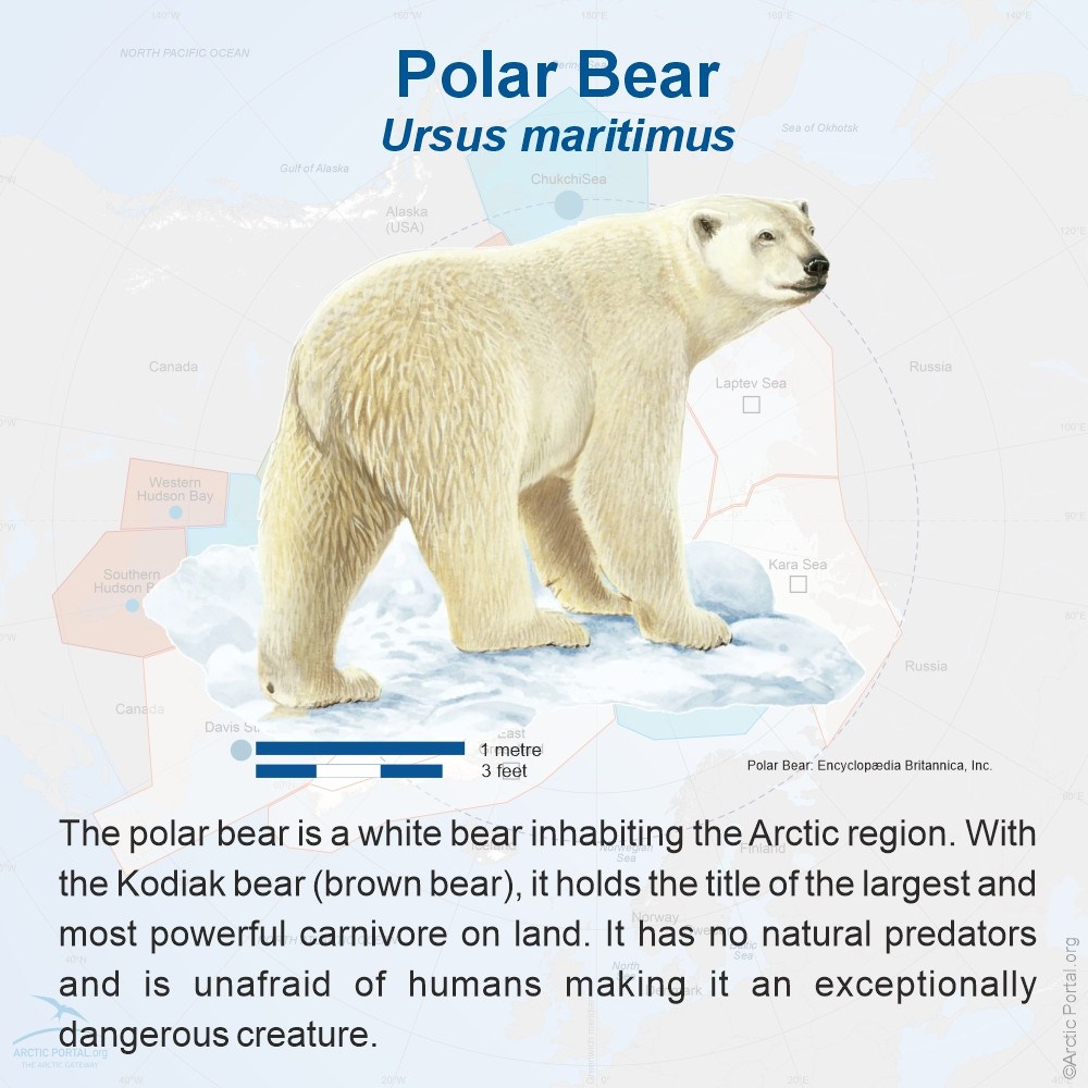
Polar bear (Ursus maritimus) – The apex predator of the Arctic, relying on sea ice to hunt seals.
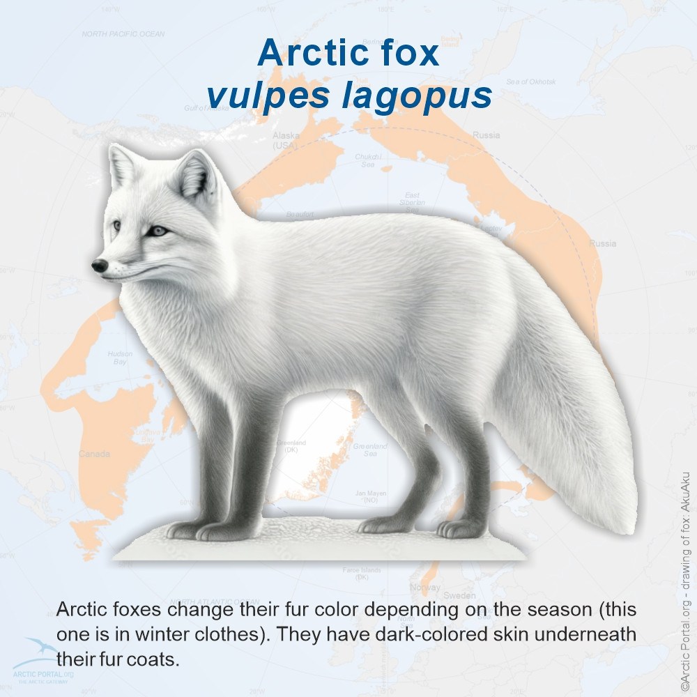
Arctic fox (Vulpes lagopus) – Known for its thick fur and adaptability to both tundra and ice.
Musk ox (Ovibos moschatus) – A shaggy herbivore that thrives in cold, open landscapes.
Arctic hare (Lepus arcticus) – Fast-moving and well-camouflaged in snow.
Reindeer/Caribou (Rangifer tarandus) – Migratory deer species adapted to cold climates.
Arctic wolf (Canis lupus arctos) – A subspecies of gray wolf found in the High Arctic.
Wolverine (Gulo gulo) – A powerful scavenger and hunter.
Moose (Alces alces) – Found in the southern parts of the Arctic region.
Arctic ground squirrel (Urocitellus parryii) – Hibernates during the winter in underground burrows.
Dall sheep (Ovis dalli) – Mountain-dwelling ruminants with impressive curved horns.
Brown bear (Grizzly) (Ursus arctos) – Found in subarctic regions.
Lemming (including Northern collared lemming (Synaptomys borealis) and Arctic lemming (Lemmus sibiricus)) – Small rodents with dramatic population cycles.
Marine Mammals (click on the text in blue to get quick fact about the animal)
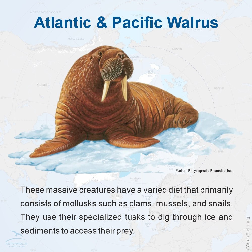
Walrus (Odobenus rosmarus) – Large tusked mammals that rest on ice floes and feed on the seafloor.
Ringed seal (Pusa hispida) – A primary food source for polar bears.
Beluga whale (Delphinapterus leucas) – Social and vocal white whales found in coastal Arctic waters.
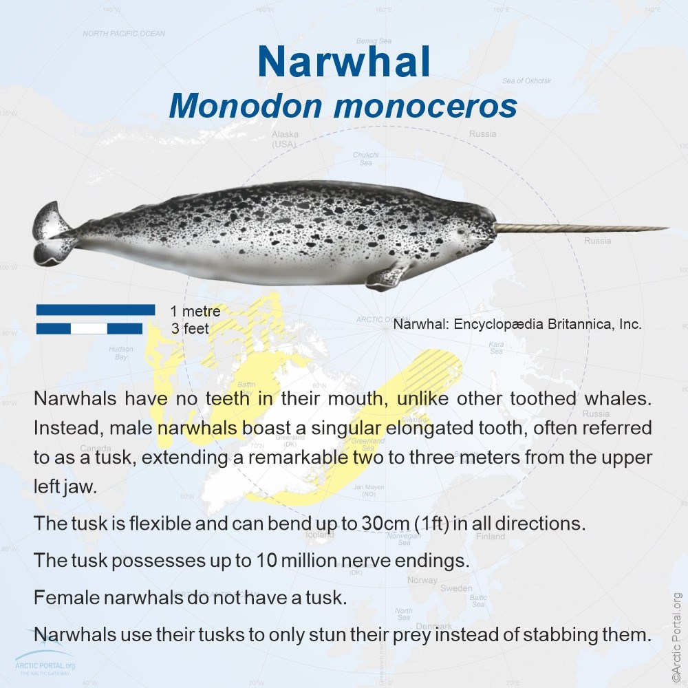
Narwhal (Monodon monoceros) – The "unicorn of the sea," known for its long spiral tusk.
Harp seal (Pagophilus groenlandicus) – Recognizable by the harp-shaped markings on their backs.
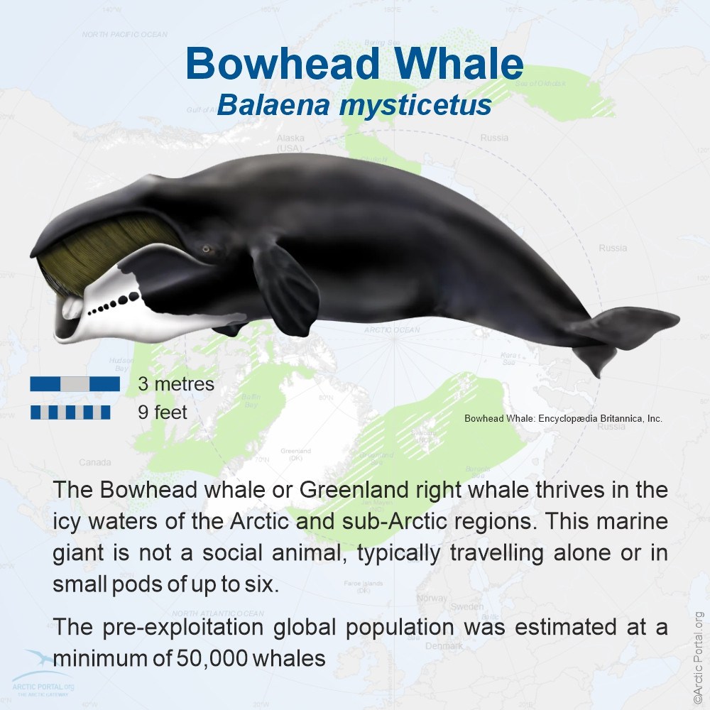
Bowhead whale (Balaena mysticetus) – Ice-adapted baleen whales that can break through sea ice.
Greenland shark (Somniosus microcephalus) – One of the longest-living vertebrates on Earth.
Orca (killer whale) (Orcinus orca) – Increasingly common in ice-free Arctic waters.
Humpback whale (Megaptera novaeangliae) – Migratory whales that feed in Arctic waters during the summer.
Bearded seal (Erignathus barbatus) – Named for their thick whiskers, which help detect prey on the seabed.
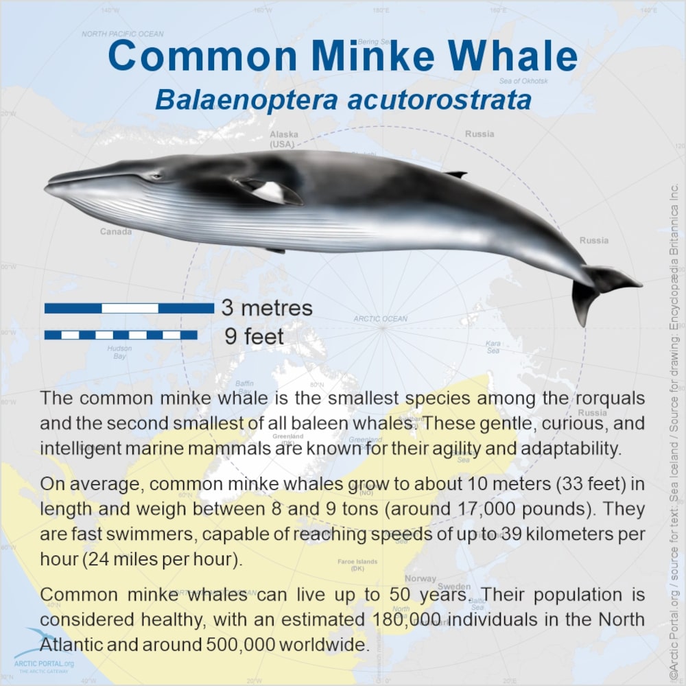
Common minke whale (Balaenoptera acutorostrata) – A small baleen whale often found in the North Atlantic and Arctic regions during summer months.
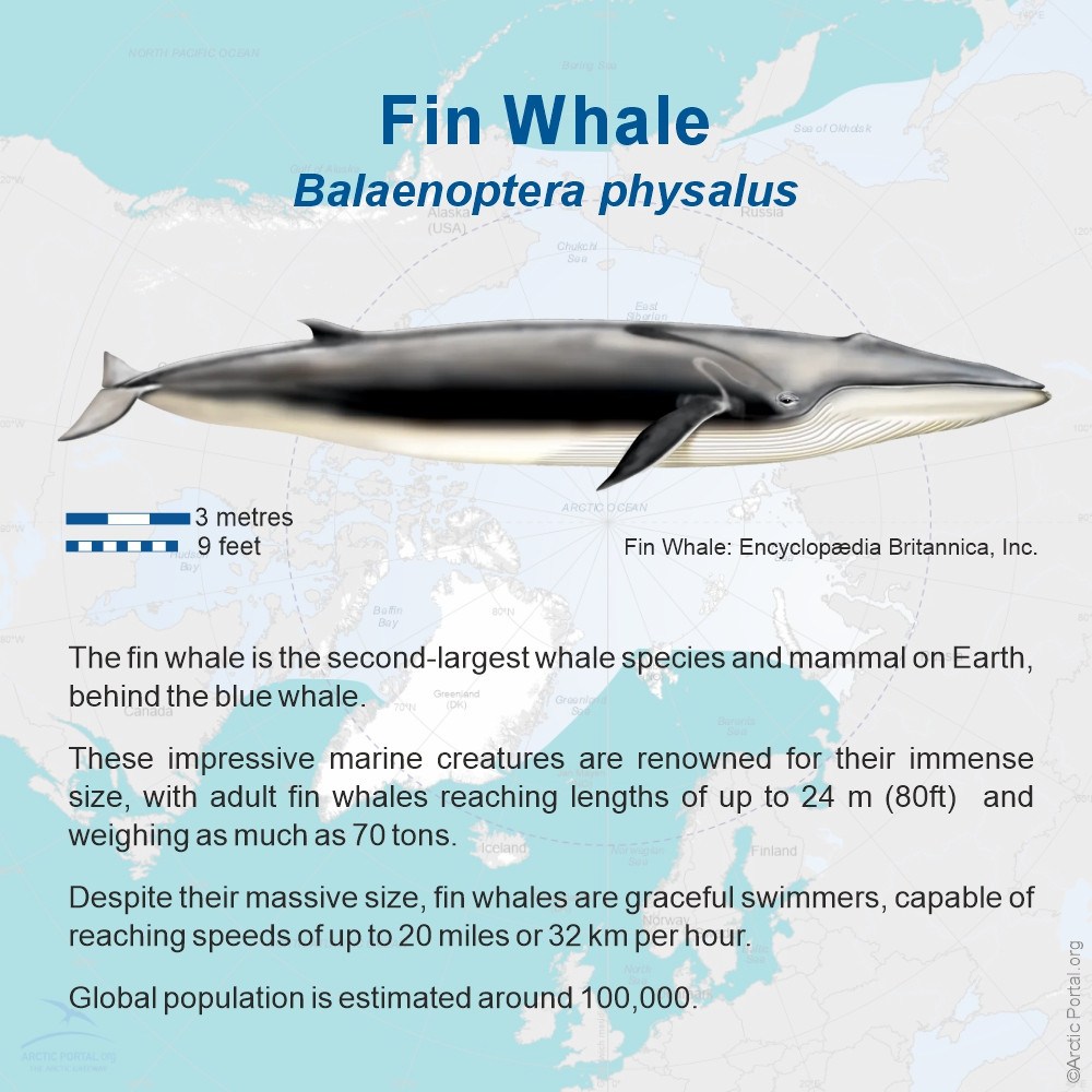
Fin whale (Balaenoptera physalus) – The second-largest whale species, frequenting sub-Arctic and Arctic seas in summer.
Birds
Snowy owl (Bubo scandiacus) – A large white owl adapted to open tundra and long daylight.
Arctic tern (Sterna paradisaea) – Famous for its epic migration between the Arctic and Antarctic.
Arctic skua (Stercorarius parasiticus) – A kleptoparasite that steals food from other birds.
Rock ptarmigan (Lagopus muta) – A ground bird that changes plumage with the seasons.
Puffins (Fratercula arctica) – Iconic seabirds that nest in Arctic cliffs.
Yellow-billed loon (Gavia adamsii) – A striking and vocal diving bird.
Tundra swan (Cygnus columbianus) – Large white swans that breed in Arctic wetlands.
Bluethroat – A colorful songbird found in tundra shrubs.
Snow goose (Anser caerulescens) – A migratory waterfowl nesting in Arctic regions.
- Details
- Written by: ofurpaur
- Category: The Arctic
- Hits: 1615
The Arctic is home to a remarkable array of islands—ranging from vast landmasses to remote volcanic outposts. These islands are not only ecologically and geologically diverse but also hold cultural, geopolitical, and historical significance. This section explores some of the most prominent islands in the Arctic region, showcasing their landscapes, wildlife, and unique features that contribute to the complexity and richness of the circumpolar world.
Diomede Islands
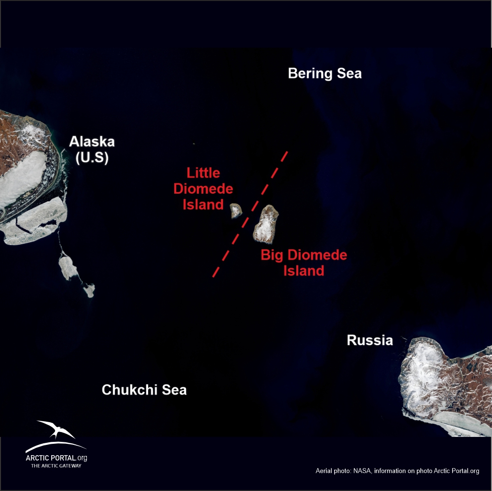 The Diomede Islands, named after the Greek explorer Diomedes, are located approximately 3.8 km or 2.4 miles apart at their closest point. Danish navigator Vitus Bering sighted the Islands on 16 August 1728, the day on which the Russian Orthodox Church celebrates the memory of the saint Diomedes, hence the name. In 1732, a Russian geodesist, Mikhail Gvozdev, determined longitude and latitude for the two islands.
When the United States purchased Alaska from Russia in 1867, it included Little Diomede or Krusenstern Island (Inupiaq: Iŋaliq). The island spans only 7.3 square kilometers. Big Diomede known as Ratmanov Island was not included in the purchase and therefore belongs to Russia. Subsequently, the two nations drew a boundary line between the islands. The passage between the islands has since been referred to as the “ice curtain”, a reference to politics rather than climate. During winter, an ice bridge usually spans the distance between these two islands, therefore at times it is theoretically possible to walk between the United States and Russia - although not legal since travel between the two islands is strictly forbidden!
See quick-fact on Diomede Islands
See also the article: The Diomede Islands – Tomorrow & Yesterday Isle
____________________________________________________________________________________________
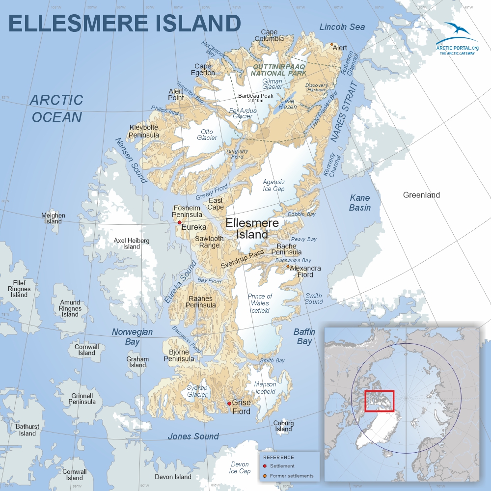 Ellesmere Island
Ellesmere Island is the third-largest island in Canada and the tenth-largest in the world. Characterized by ice-covered mountains, deep fjords, and expansive ice shelves, it stretches approximately 830 km long and 645 km wide, covering an area of about 196,235 km2. Barbeau Peak, the island’s highest mountain and the highest point in Nunavut, rises to 2,616 m.
Quttinirpaaq National Park, located in the northeastern corner, is one of Canada's most remote protected areas and the second-most northerly park on Earth after Northeast Greenland National Park. The park’s name means “top of the world” in Inuktitut.
About 40% of Ellesmere Island is glaciated, making it one of the most heavily glaciated regions in the Canadian Arctic. Despite its icy landscape, it is also one of the driest parts of the Arctic, with a desert-like climate and sparse precipitation.
Though largely uninhabited today, population in 2024 according to the World Population Review was 144. The island has a few settlements and research stations.
See quick-fact on Ellesmere Island
See also the article: Ellesmere Island: The Remote Arctic Frontier
____________________________________________________________________________________________
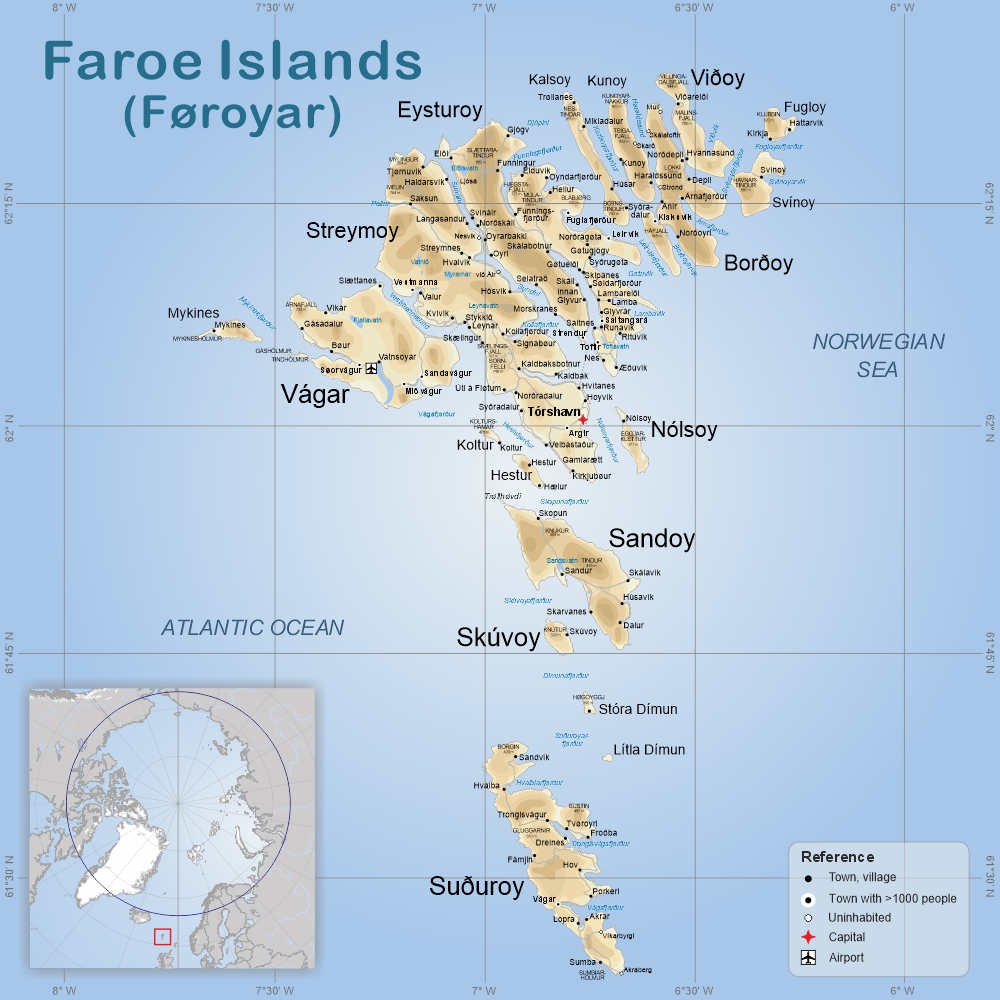 Faroe Islands
The Faroe Islands are an autonomous territory of the Kingdom of Denmark. They consist of 18 rugged islands situated between the Norwegian Sea and the North Atlantic Ocean, roughly halfway between Iceland and Norway. Covering an area of 1,393 km2, the islands feature Europe’s highest sea cliffs, fjords, green hills, and over 1,100 km of coastline.
The highest point is Slættaratindur at 882m on the island of Eysturoy. Tórshavn, the capital located on Streymoy Island, is home to about 23,000 people. The official language of the islands is Faroese.
Despite their high latitude, the climate is moderated by the Gulf Stream, leading to cool summers, chilly winters, frequent fog, and strong winds.
The weather in the Faroe Islands is famously unpredictable, with sudden changes that can bring sunshine, rain, and fog all in one day.
See quick-facts on the Faroe Islands
____________________________________________________________________________________________
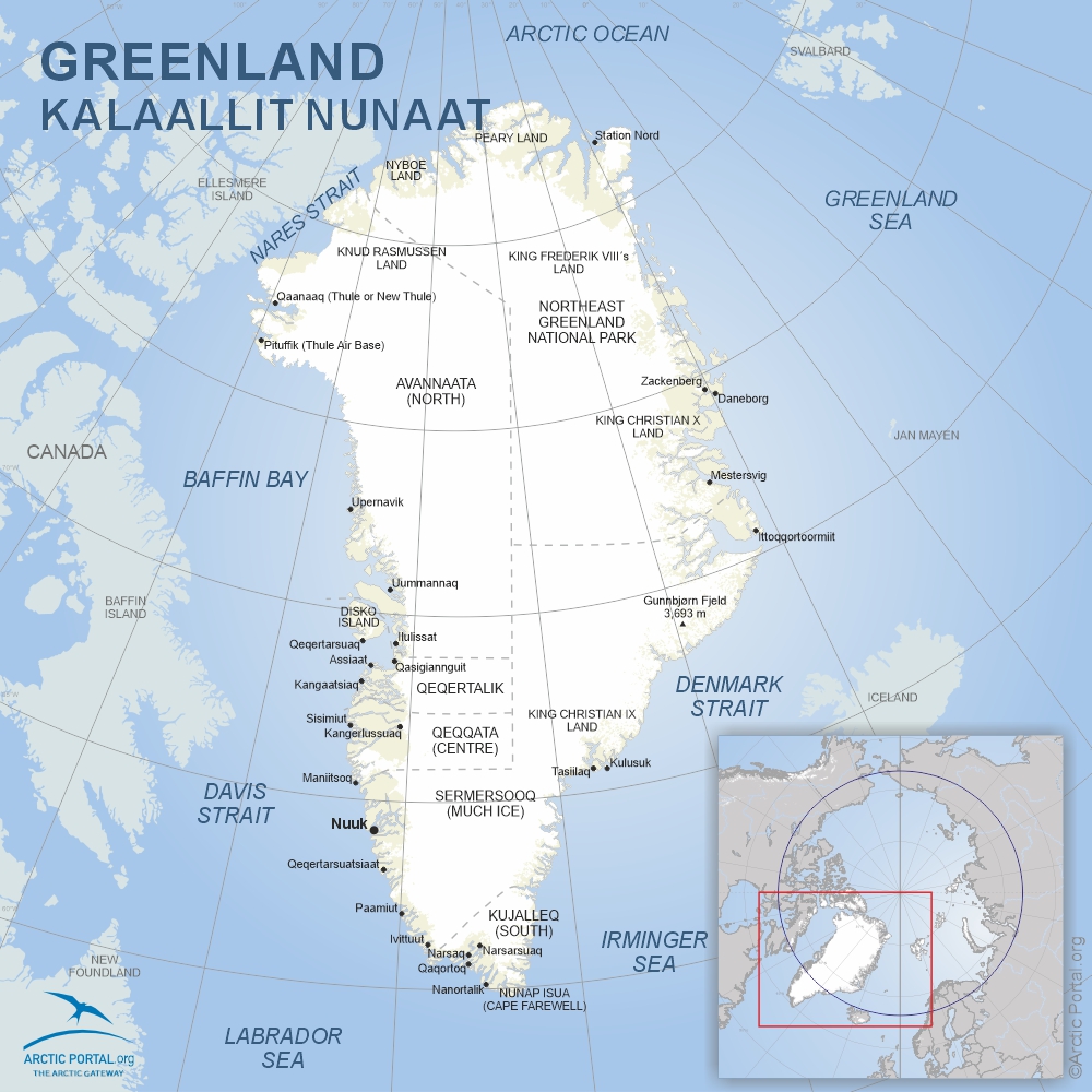 Greenland
Greenland is the world’s largest island, covering about 2.17 million km2—roughly 20 times the size of Iceland. Around 1.76 million km2 is covered by ice and glaciers. The coastline stretches for approximately 39,330 km, making it one of the longest in the world. The island’s highest point is Gunnbjørn’s Fjeld at 3,693 m.
Roughly two-thirds of Greenland lies above the Arctic Circle. Its coastal zones host tundra ecosystems, with permafrost underlying much of the terrain. The northeast section is home to the world’s largest national park—the Northeast Greenland National Park—covering nearly 972,000 km2.
Greenland’s coastal waters support marine mammals like seals, walruses, and whales. On land, polar bears, Arctic foxes, reindeer, wolves, and musk oxen roam. Over 230 bird species, including sea eagles and puffins, nest along its coasts and feed on the region’s fish-rich waters.
____________________________________________________________________________________________
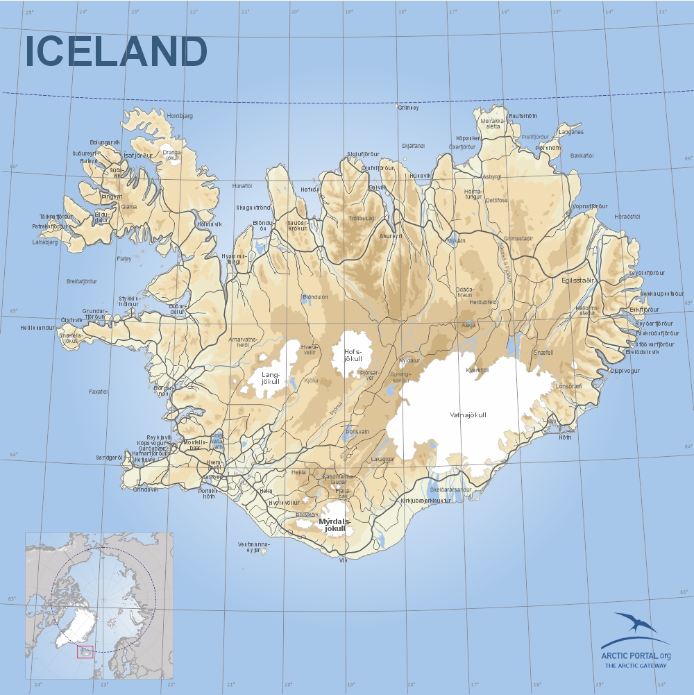 Iceland
Iceland, the second-largest island in Europe, spans 103,000 km2 and lies atop the Mid-Atlantic Ridge. It’s known for volcanic and geothermal activity, with numerous geysers, hot springs, and lava fields. About 10% of the island is glaciated, and over 50% is barren. The fertile areas mainly lie along the southern and western coasts.
Thanks to the North Atlantic Current, Iceland enjoys a relatively mild climate compared to other places at similar latitudes. Coastal waters remain ice-free year-round, and the Gulf Stream helps regulate temperatures, although occasional shifts in ocean currents can lead to more extreme weather.
The population of Iceland is about 390,000 (2025).
____________________________________________________________________________________________
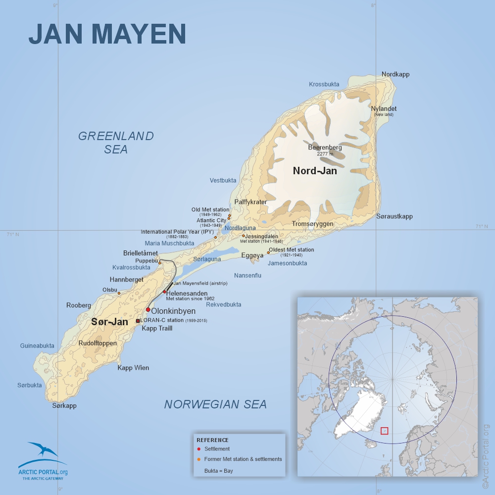 Jan Mayen
Jan Mayen is a remote volcanic island under Norwegian jurisdiction, located at 71°N, 8°W. It lies roughly 600 km northeast of Iceland, 500 km east of Greenland, and 1,000 km west of mainland Norway. The island is about 55 km long and covers 373 km2.
The island’s dominant feature is Beerenberg, the northernmost active volcano in the world, which last erupted in 1985. It rises to 2,277 m and is glacier-covered. The flatter southwest part of the island, Sør-Jan, lacks glaciers. The island is named after Jan Jacobszoon May, a Dutch sea captain who visited in 1614.
Jan Mayen has been a nature reserve since 2010 with strict visitation regulations. There is no permanent population on the island, only personnel.
____________________________________________________________________________________________
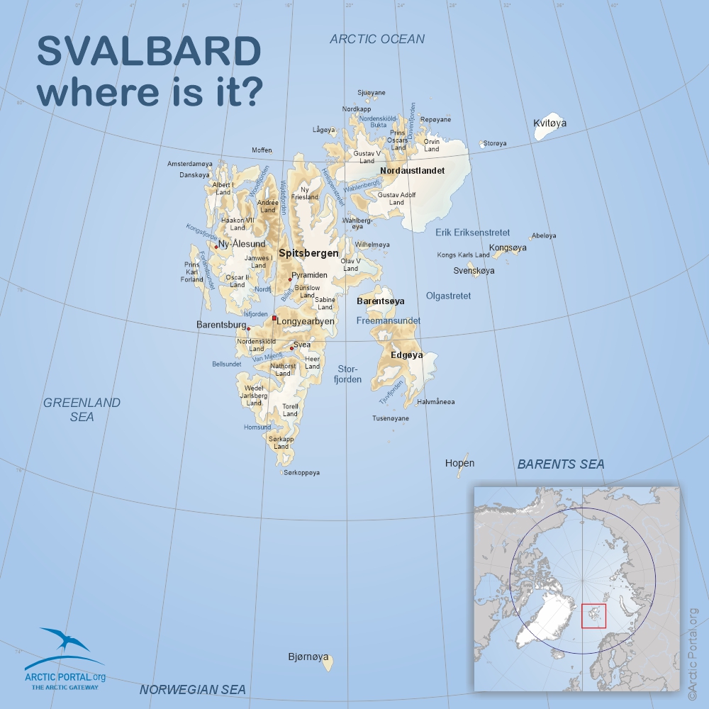 Svalbard
Svalbard is a Norwegian archipelago situated between 74° and 81° N latitude. It covers 62,700 km2, with most settlements clustered on Spitsbergen Island. The largest settlement, Longyearbyen, has around 2,400 residents from over 50 countries. Other settlements include Barentsburg, Ny-Ålesund, and the meteorological outposts on Hopen and Bjørnøya.
Svalbard’s landscape features towering mountains, glaciers, and Arctic tundra. The region hosts a wide range of Arctic wildlife, including polar bears, reindeer, walruses, beluga whales, Arctic foxes, and numerous seabird species such as guillemots and puffins.
____________________________________________________________________________________________
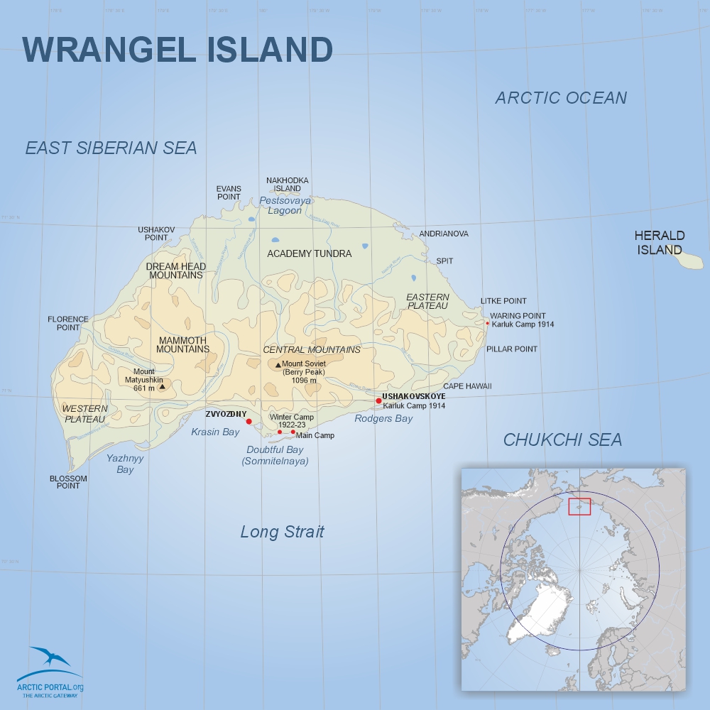 Wrangel Island
Wrangel Island lies at around 71°N, 179°W, off the northeastern coast of Russia. It is about 150 km long and 80 km wide, with a total area of 7,600 km2. Unique among Arctic islands, it remained unglaciated during the last Ice Age, preserving ancient ecosystems and soils largely undisturbed for millennia.
The island supports over 400 plant species—the richest Arctic island flora—along with a variety of endemic wildlife. Its preserved tundra ecosystems provide insights into the Pleistocene epoch. Wrangel is also a critical habitat for polar bears, walruses, and migratory birds.
See quick-facts on Wrangel Island
Wrangel Island: Land of Mammoths, Explorers, and Polar Bears
See map of Wrangel Island
- Details
- Written by: ofurpaur
- Category: The Arctic
- Hits: 1060
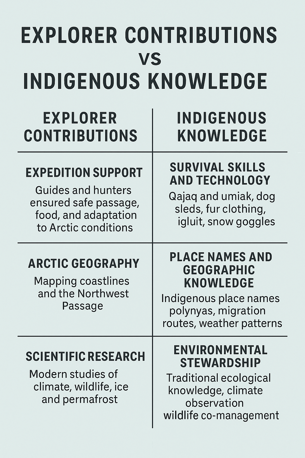 While European and North American explorers are often celebrated in the history of Arctic exploration, it was—and still is—the Indigenous peoples of the Arctic who made survival in this harsh environment possible. Their traditional knowledge, skills, and guidance were instrumental to many expeditions and remain crucial in today’s scientific research and environmental monitoring.
Survival Skills and Technology
Indigenous groups such as the Inuit, Sámi, Chukchi, and Yupik developed technologies perfectly adapted to the Arctic environment long before outsiders arrived:
- Qajaq (Kayak) and Umiak for navigating icy waters.
- Dog sleds (qamutiit) for transportation across ice and snow.
- Clothing made from animal skins and fur for warmth and mobility in extreme cold.
- Snow goggles, made of bone or wood with narrow slits to prevent snow blindness—an early form of sunglasses.
These innovations were often adopted by explorers who otherwise would not have survived the Arctic’s severe conditions.
Guides, Hunters, and Teachers
Many expeditions would have failed without the expertise of Indigenous guides, hunters, and interpreters:
Ipiirvik (Ebierbing), an Inuk guide, played a critical role in Charles Francis Hall’s 19th century expeditions. He was born near Cumberland Sound, Nunavut. Known for his navigation, hunting, and survival skills, which were critical to Hall´s success. He and his wife Taqulittuq were the best-known and most widely-travelled Inuit in the 1860s and 1870s.
Minik Wallace, a young Inughuit boy from northern Greenland, was brought to New York by Robert Peary in 1897. Though not a traditional explorer, his life symbolizes the complex and often exploitative relationships between Indigenous peoples and explorers. Minik later returned to Greenland but did found it difficult to reintgrate into Inuit life and later returned to the United States. Minik died during the influenza pandemic of 1918, at around 28 years old.
Indigenous families often accompanied explorers, helping them learn how to build igluit (snow houses), hunt, and travel safely over sea ice.
Place Names and Environmental Knowledge
Indigenous peoples named landscapes long before they were mapped by outsiders. Many place names now used internationally come from Indigenous languages and reflect important geographic and ecological knowledge. This includes:
- Locations of polynyas (areas of open water in sea ice).
- Migration routes of animals.
- Seasonal variations in weather and sea ice patterns.
This knowledge has been passed down through generations and is increasingly recognized in contemporary Arctic research.
Today’s Role in Science and Stewardship
Today, Indigenous communities are key partners in:
- Climate change research (e.g. monitoring permafrost thaw, ice conditions, and species migration).
- Co-management of wildlife (e.g. narwhal, caribou, polar bear).
- Community-based monitoring programs and citizen science initiatives.
- Environmental stewardship through traditional ecological knowledge (TEK), which complements modern scientific methods.
- Details
- Written by: ofurpaur
- Category: The Arctic
- Hits: 828
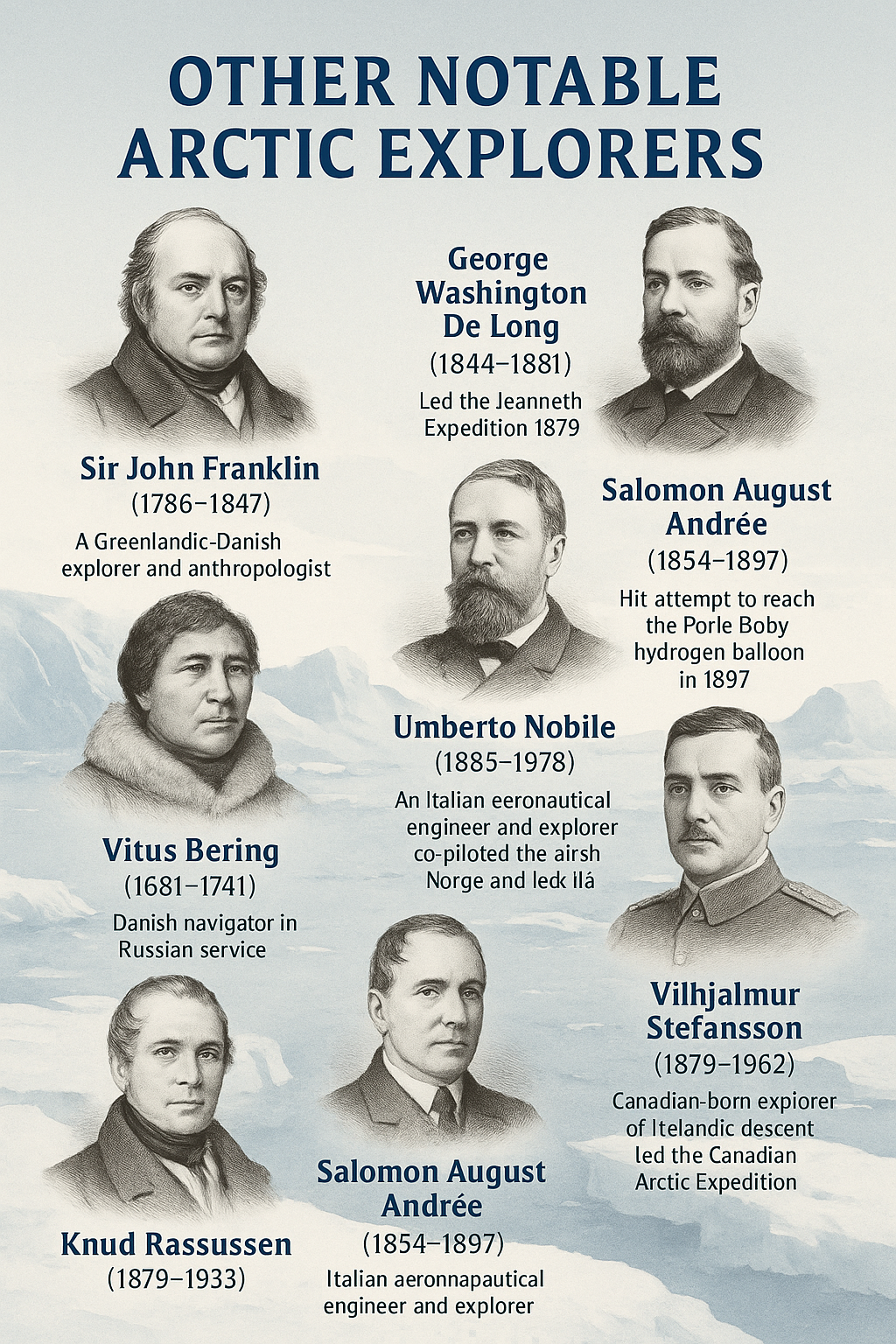 While Roald Amundsen, Robert Peary, and Fridtjof Nansen are among the most renowned figures in Arctic exploration, many others have made vital contributions to our understanding of the region, often at great personal risk. Their expeditions, whether successful or tragic, have shaped the modern map of the Arctic, advanced scientific knowledge, and deepened our appreciation of polar cultures and environments.
Below is a list of several key explorers whose journeys helped define the Arctic narrative:
Sir John Franklin (1786–1847)
Led the ill-fated 1845 British expedition to chart the Northwest Passage. The disappearance of his ships, HMS Erebus and HMS Terror, sparked numerous search missions and remains one of history's greatest polar mysteries.
Knud Rasmussen (1879–1933)
A Greenlandic-Danish explorer and anthropologist, Rasmussen led the Fifth Thule Expedition (1921–1924), traversing the Northwest Passage by dog sled and documenting Inuit cultures across the Arctic.
Vitus Bering (1681–1741)
A Danish navigator in Russian service, Bering led the First and Second Kamchatka Expeditions in the 18th century. He explored parts of the Arctic and the North Pacific, lending his name to the Bering Strait and Bering Sea.
William Edward Parry (1790–1855)
A British naval officer who made several early 19th-century voyages in search of the Northwest Passage. He reached a record northern latitude of 82°45′N in 1827—an achievement that stood for nearly five decades.
George Washington De Long (1844–1881)
An American naval officer who led the Jeannette Expedition (1879–1881), attempting to reach the North Pole via the Bering Strait. The ship became icebound and was ultimately crushed; De Long and many of his crew perished, but valuable scientific data was recovered.
Salomon August Andrée (1854–1897)
A Swedish engineer who tried to reach the North Pole by hydrogen balloon in 1897. The expedition ended in tragedy, but the remains and journals were discovered in 1930, offering a haunting window into the ordeal.
Umberto Nobile (1885–1978)
An Italian aeronautical engineer and explorer. He co-piloted the airship Norge with Roald Amundsen over the North Pole in 1926, and led the Italia expedition in 1928, which ended in a crash and a dramatic international rescue effort.
Vilhjalmur Stefansson (1879–1962)
A Canadian-born explorer of Icelandic descent, Stefansson led the Canadian Arctic Expedition (1913–1916), mapping vast areas of the Arctic coastline. His ethnographic work with Inuit communities and controversial theories on Arctic colonization have made him a complex but influential figure in polar history.
- Details
- Written by: ofurpaur
- Category: The Arctic
- Hits: 2544
Climate Change or Global Warming refers to the increase in the average temperature of the Earth's near surface air and oceans since the mid 20th century.
Climate Change is, in the eyes of many, the key issue in the Arctic and one of the key issues faced by human kind as a whole. Climate change has been highly disputed and there are those who maintain that human induced climate change does not exist and the swift warming occurring over the two last centuries is a part of the earth's natural cycle.
Although most scientists agree on that the globe is becoming warmer, predictions on how rapidly Arctic ice will retreat often varies greatly amongst them.
The schedule is however not as important as the results of this development and the possibility of the ice-free Arctic to become a lucrative shipping route.